Using Geographic Coordinates
You can use geographic Latitude and Longitude coordinates to place devices on your map. This can be useful if you have many devices at different locations. The procedure is relatively simple:
- Create a new map on which you want to place the devices.
- Obtain a map image you want to use as the background for the map. You can scan your own map to create the image, or get one from one of the sites listed below. Intermapper can import image files in PNG, JPEG, or GIF format.
- Set the image as the background for your map as described in Background Images (Pg. 1).
- Set benchmarks in the map as described below. This sets the relationship between your map image and real geographic coordinates.
- Create a text file containing a list of your devices with their IP addresses and Latitude and Longitude coordinates. You can specify many other parameters for each device within this file as well. For more information, see Importing Data Into Maps (Pg. 1). A sample data file is shown below, containing geographic coordinates.
- Import the text file. The devices appear at the correct location on the map.
Setting Benchmarks in Your Map
A benchmark is an icon on a map that specifies the latitude and longitude of that point. Intermapper uses the benchmarks to determine the proper location for icons on the map.
To place a benchmark on a map:
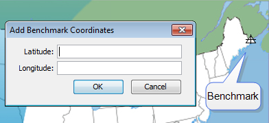
- Right-click (CTRL-click) a known location (on for which you know the actual latitude and longitude) in the map's background image and choose Add benchmark. The Add Benchmark Coordinates window appears.
-
Enter the latitude and longitude for the point. A small triangular icon
appears to represent the benchmark. Intermapper supports multiple formats for latitude and longitude. (See below)
- Follow steps 1 and 2 to enter a second benchmark to complete the geographic information. Your map is now ready for you to import devices with specified geographic coordinates.
To remove a benchmark on a map:
- Right-click (CTRL-click) an existing benchmark, choose Remove benchmark. The benchmark disappears from the map.
To remove both benchmarks from a map:
- Right-click (CTRL-click) anywhere in the map's background image and choose Clear benchmarks. Both benchmarks are removed from the map.
Accepted Geographic Coordinate Formats
Intermapper supports a wide variety of formats for entering geographic coordinates. Any coordinate can be entered as follows:
- Decimal degrees: 43.692 or 72.272
- Degrees, minutes, seconds: 43:16:34.56
- Degrees with decimal minutes: 43:23.341
- Use W and S suffixes as alternatives to negative values.
Sample accepted formats:
- [+|-]dd.dd:mm.mm:ss.ss
- [+|-]dd.dd:mm.mm
- [+|-]dd.dd
- [+|-]dd.dd mm.mm ss.ss
- [+|-]dd.dd mm.mm
Allowable suffixes:
- s
- n
- e
- w
- S
- N
- E
- W
Acceptable Data Elements (in order)
- an optional negative sign
- a real number
- anything except letters, digits, -, or .
- a real number
- anything except letters, digits, -, or .
- a real number
- an optional ending directional notation (N, S, E, W, n, s, e, w (depends on the field)) or (in the case of 43˚ 16' 23)
Importing Devices with Geographic Coordinates
You can create a tab-delimited file with information about the devices to be added to the map. This information can include any of following fields: Name, IP Address, DNS name, port, type of device, SNMP community string, latitude, longitude, and many other fields. Fields left unspecified are filled with default values. For more information, see Importing Data Into Maps (Pg. 1).
An import file is formatted as follows:
- Line 1 specifies the format of the following lines - it specifies the file format (tab in the example below), the table to be filled (devices) and the order of the fields. MapName, Address, and Probe must be specified; the remainder are optional.
- Remaining lines contain the data for the devices you want to import - Each device occupies a single line, and the data columns are separated by tabs (a tab-delimited file.) Each column corresponds to a field in the fields specification of Line 1.
In this example import file, there are five fields to import. Intermapper places these items on the map named MapA, using the address specified to create HTTP probes. They are placed at the indicated latitude and longitude.
# format=tab table=devices fields=MapName,Address,Probe,Latitude,Longitude
MapA	192.168.2.100	http	43.3	-72.0
MapA	192.168.2.101	http	43.9	-72.3
MapA	192.168.2.102	http	43.8	-72.8
MapA	192.168.2.103	http	43.0	-72.4
MapA	192.168.2.104	http	43.2	-72.3
MapA	192.168.2.105	http	43.6	-72.2
Map Sources
The following mapping services are available through the web:
| Web-based Service |
Description |
|---|---|
| Google Image Search |
http://www.Google.com/imghp?hl=en&tab=wi&ie=UTF-8&q=
|
| Maporama |
http://www.maporama.com
|
| Mapblast |
http://www.mapblast.com
|
| National Atlas |
http://www.nationalatlas.gov
|
| terraserver.com |
http://www.terraserver.com
|
| Microsoft Research Maps |
http://msrmaps.com/
|
| US Census Bureau |
http://www.census.gov/geo/www/maps
|
| Yahoo! Listing of Map Resources |
http://dir.yahoo.com/Science/Geography/Cartography/Maps/Interactive/
|
| dmoz Open Directory |
http://dmoz.org/Science/Social_Sciences/Geography/Geographic_Information_Systems/
|
| Geocode.com |
http://www.geocode.com/
|
| Radio Mobile |
http://www.cplus.org/rmw/english1.html
|