Exporting Information to Google Earth
Intermapper exports the following information so that Google Earth can place devices in the proper location. This information is exported as a .KML file compatible with Google Earth.
Each Intermapper map appears as a place in the left pane of Google earth. Items are shown as follows:
- Devices are represented by their status badges (green, yellow, orange, red circle icons)
- Network ovals are shown as small circles.
- Links between devices are shown as lines connecting the icons.
- A Status window for each of the above items displayed when you click the item.
To be displayed in Google Earth, a device must have geographic information; devices that do not have geographic information are not displayed at all.
Geographic coordinates can be set in the following ways:
- Explicitly - by using Set Latitude and Longitude for each device. You can set latitude and longitude values for many devices at once by importing a text file containing the correct information (Pg. 1).
- Implicitly - When benchmarks are are placed on a map, the device's latitude and longitude are inferred from the x/y position on the map, relative to the established benchmarks. Use the Insert menu's Map Benchmark... (Pg. 1). to add benchmarks. Use of benchmarks is inherently less precise than using explicit coordinates.
In the case where both explicitly set coordinates and benchmarks are used, Intermapper uses the explicit coordinates and ignores the benchmarks.
How it Works
- Google Earth requests information from the Intermapper server using HTTP. Consequently, the Intermapper web server interface must be enabled in the Server Settings.
- The Google Earth connection uses the same authentication method as the web interface; you must have appropriate web access permissions for any map you wish to view in Google Earth. (Google Earth will prompt you for the username and password.)
- Google Earth does not need to be installed on the Intermapper server, though its machine must have appropriate access permissions established in the Intermapper web server firewall.
- Google Earth uses a "Network Link" with a URL that Google Earth uses to request information from Intermapper.
How to Use it
The easiest way to get the URL is through the Intermapper web interface.
- Download and install Google Earth.
- From the Server Configuration section of the Server Settings window, click Web Server. The Web Server settings pane appears in the right pane.
- Make sure the web server is running, then click the URL to launch a browser with the Intermapper Web interface.
- In the Intermapper web interface, click Map List. A list of maps on your server appears.
- Click the link to a map that contains latitude/longitude information, either implicitly or explicitly. The map appears in the browser.
- At the bottom of the map, click View this map in Google Earth. This is a link to the map's .KML file, a data file used by Google Earth. Assuming Google Earth has been installed properly, your browser offers to use Google Earth to open the file.
If everything is set up properly, the status badges for your devices hover over the surface of the Earth in appropriate locations.
To view a device's status window:
Click the device's badge. The device's Status window is displayed in the Google Earth window.
The map refreshes automatically every 5 minutes.
What You See
The images below show the original map, the mapped devices displayed from two different zoom levels, and the status window for one of the devices.
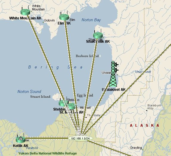
Original map in Intermapper
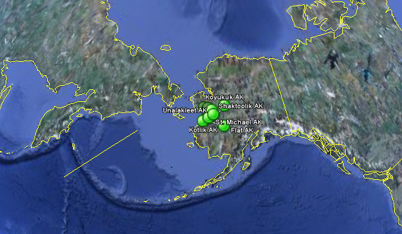
Wide view in Google Earth
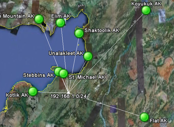
Closer view in Google Earth
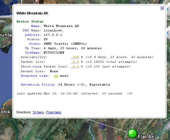
Status window in Google Earth